Background
When taking GIS 203 (Cartography), my final project was creating an orienteering map with GIS Desktop using the International Orienteering Federation (IOF) cartographic standards. The map’s purpose is to teach orienteering to first year Scouts in order to pass specific requirements. As a result, the map is part of a two-page product containing information about calculating a bearing, estimating height, and space to enter control point information.
For GIS 295, I want to explore how to create the same map with the same features with a general purpose map creation tool such as ArcGIS Online and a specific orienteering map creation tool called Open Orienteering Map (http://oomap.co.uk/). I plan to use the three blogs required to describe how the orienteering maps are created with each system – ArcGIS Desktop, ArcGIS Online, and Open Orienteering Map.
OpenOrienteeringMap V2.4 Description
OpenOrienteeringMap (OOM) is a custom version of Open Street Map created by Oliver O’Brien that uses many IOF cartographic specifications (IOFmapping). The purpose of OpenOrienteeringMap is to easily create orienteering maps using the OpenStreetMap spatial data set of the world and the map rendering toolkit Mapnik. The displayed view is dynamically created in one of four base map configurations as the user pans or zooms in or out in supported fixed-scale intervals. Scales 1:7000 and 1:14000 (zoom levels 16, 15) are most commonly used for orienteering maps. The displayed scale can be used to generate PDF files with associated features.
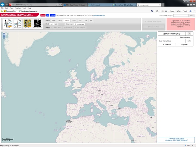
To view any region in North America, the “Global” button located at the top of the main frame must be selected to display everything but the UK and Ireland. The following shows the opening screen with the Global button selected (note that like Openstreetmap.org, the first map displayed is always Europe:
Base Maps
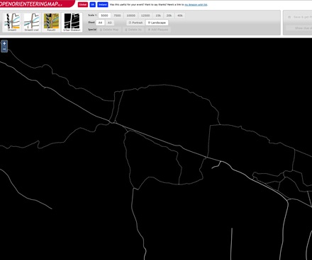
Four base maps are available: Street-O, Street-O Xrail, Pseud-O, and Urban Skeleton. The Street-O map setting originates from the Street-O maps used for informal orienteering races in London and other areas around the UK. Only roads, tracks, paths, rivers/lakes and railways are shown; the maps are high-contrast (black on white) and have little color. The few colors that are on the map – for major roads, park land, and water features use the “official” ISOM standard colors for these features. The Pseud-O base map emulates the look and feel of standard orienteering maps, but in many regions, does not have the detail necessary in OSM. The rendering is done on-the-fly, but with caching. The two styles are available from zoom levels 12 to 18. Levels 15 & 16 roughly correspond to scales that would be used for conventional orienteering. The following screenshot shows a Street-O view of the Fraser Preserve in Great Falls:

The only difference in Great Falls is the open woodland designation for the non-park land regions, where they are shown as white in Street-O. The following screenshot shows a Pseud-O view of the Fraser Preserve in Great Falls:

The following screenshot shows an Urban Skeleton view of the Fraser Preserve in Great Falls:
Map Creation Procedure
Perform the following steps to create an orienteering map, control point clues, and generate the PDF files to be incorporated into a finished product:
- Select “Global” for North America and focus on the Fraser Preserve in Great Falls, Virginia, at 1:5000 scale.
- Select base map for “Pseud-O”
- Select Landscape or Portrait, click in the desired map center. If necessary, drag the blue marker to re-center the map. A frame will appear over the base map in portrait or landscape orientation.
- On the right, click the pencil edit icon to display the map title. I entered Camp Fraser Orienteering, then press OK.

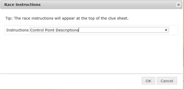
5. Select the next edit icon to modify the race instruction title:
6. Click on the Start/End point on the map to display the following dialog:
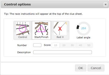
7. Click on the next Control point on the map to display the following dialog:
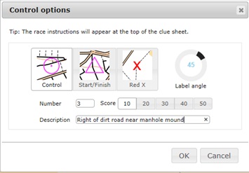
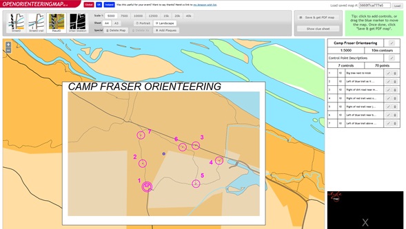
Enter the numbers and descriptions for each control point. Set the location of the number label by rotating the label angle control. Repeat for all the control points resulting in the following map:

8. Click on “Save & Get PDF Map” button and the following message appears:

Click OK and save the automatically downloaded oom.PDF file located in the Download directory.
The completed map appears on screen within a map frame containing the control points:
9. To retrieve the above map, enter the code 5668f7ca777e5 into the “Load saved map #:” and select the “Load” button.
10. To delete the above map from the display, select the “Delete Map” button.
Output Options
For orienteering applications, the created map product will have to printed and used off-line. OOM makes PDF map file generation easy using the “Save and Get PDF Map” and “Show Clue Sheet” buttons.
- To view the generated PDF file when “Save and Get PDF Map” button selected, search for OOM.PDF in the download directory and display:

2. Click the “Show clue sheet” button to display the seven generated control points:

3. Click “Print clue sheet” to display the print prompt and output the file as a PDF.
4. Incorporate the two PDF files into a complete orienteering document.
Conclusion
As evident from the above procedure, it is easy to create a usable orienteering map. The base map is at a small enough scale to map a small area. Many cartographic features, including trails, roads, control points, start/end point use IOF cartographic standard. There are some things missing from the map however; 5 meter topographic lines, exact IOF-specified land features, and free text labeling. Since the Open Street Map doesn’t have topography, it would be too processor intensive to dynamically render topo lines. Because of this dynamic rendering of the custom maps, a high-speed Internet connection is necessary.
Creating custom maps using the free OSM spatial data set and a private data set containing unique cartographic features makes OOM possible and a powerful paradigm. As a result, thematic, web-based mapping that addresses the needs of specialized communities is now possible.
Reference Summary:
http://blog.oobrien.com/2009/12/oom/
http://www.maproomblog.com/2010/02/openorienteeringmap.php
https://github.com/oobrien/oomap
http://blog.oomap.co.uk/2009/12/oom/
http://wiki.openstreetmap.org/wiki/OpenOrienteeringMap
